
Wild and Wonderful West Virginia
- cindybabington
- Feb 13, 2022
- 8 min read
Updated: Mar 7, 2022
West Virginia's very appropriate tagline on their Welcome signs is "Wild and Wonderful." We had so much fun exploring the eastern West Virginia, including the Greenbrier Valley, the New River Gorge National Park, Pocahontas County and the area around Harper's Ferry. Around every bend there were forests, photogenic rivers, rhododendron forests, historical markers, river gorges, and wildflowers. And the nicest people. We probably met and chatted with more people on this trip than any trip we have ever taken. We also stopped in Ohio coming and going to break up the trip.

Olive Branch Campground, Oregonia, OH
What a great campground. The Olive Branch Campground's sites are spacious and ours backed up to a wooded area. There is a nice walking trial through the woods, a small pool, playground and a pond for fishing. Even though we were there over the 4'th of July weekend, it was very calm and the other campers were very respectful. The campground catered to RVs more so than tent campers, and each site had full hook-ups . The campground was only about three miles from a trailhead on the Little Miami Scenic Trail. We would definitely return.
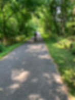
Little Miami Scenic Trail
The Little Miami Scenic Trail is one of our favorite trails - anywhere. The trail is 78 miles long and runs from just outside Cincinnati to Springfield. We had two days of riding in Ohio. The first day we rode 36 miles round trip from Oregonia trailhead south to the Monkey Bar and Grill which is between Kings Mill and Loveland. We would have ridden to Loveland but at the time the road crossing was blocked off from cyclists due to construction. The path going south is very shaded, scenic and paved. We were disappointed that the Cartridge Brewery was closed on this particular day. The Monkey Bar and Grill is a good refreshment stop as are the many places in Loveland.
Our second ride was a 40 mile round trip north from Oregonia to Xenia. We stopped in Spring Valley on the way back and had a fantastic lunch at Slim's Bar and Grill. It was a very hot day and the trail going north is shady, but not quite as shady as the trail to the south. It was still a very enjoyable ride.
Slim's Bar and Grill, Spring Valley, OH
Slim's is a Do Not Miss. It's open seven days a week and is just off the bike path. I had the cheese quesadilla, which was very good, but the real star was my husband's fried bologna sandwich. How did I get to be this age never having had a fried bologna sandwich! It was delicious. Bud Lite and Miller Lite are on tap, but there are plenty of bottles in the cooler to choose from if you prefer something different. Our server is going into occupational therapy so she and Pat had a conversation about graduate schools. Really great little place!

Greenbrier River RV Park, Alderson, WV
The Greenbrier River RV Park www.greenbrierriver.com campground was fine. It was right on the Greenbrier River and you could do float, kayak and canoe trips from the campground. There were full hook-up sites and tent sites (right on the river). The sites were pretty big and most were shaded. It was close (less than 15 minutes) to Lewisburg and to the Greenbrier River Trailhead in Caldwell. There were no walking paths or bike paths in the campground which was my only issue. Some people didn't like the trains that passed by periodically, but I like trains so no complaints here. We took a day to explore the New River Gorge National Park. Beautiful!
Greenbrier River Trail (south end)
The Greenbrier River Trail is 77 miles long and runs from Caldwell at the Southern edge to Cass Scenic Railroad State Park at the Northern most point. We rode 44 miles roundtrip from Caldwell (which was about 15 minutes from our campground) to Renick. The ride was very scenic and followed the river the entire way. There were some amenities at the trailheads like restrooms and benches, but no place to get food or water. Trail was in okay shape - it would be a tough ride on a road bike.


Jackson River Scenic Trail
This 14 mile trail is in the Allegheny Highlands of western Virginia. It begins in Intervale, just north of Covington and ends at the Allegheny/Bath County Line. We rode the entire trail and enjoyed every minute of it. River views, rock formations, beautiful wildflowers were just some of the sights along the way.


New River Gorge National Park
This park is amazing! One of the oldest rivers on the continent flows through deep canyons creating this gorgeous gorge. We enjoyed our visit here so much and we were surprised that it was not crowded at all.
We hiked the Endless Wall Trail to Diamond Point to be able to get a birds eye view of the New River rapids and the gorge. It was a little over two-mile roundtrip hike - straight uphill and then straight downhill.
A couple different park rangers had told us about a trail suitable for bike riding that runs along the New River. We drove to Thurmond and eventually found the Southside Trail that runs along the river for six miles. Both rangers described the trail as "easy" and "flat." We couldn't find the trail as it was a bit overgrown which maybe should have been our first clue about the trail! We asked a couple if they knew where the trail was and they pointed us in the right direction. In asking if it was suitable for bikes, they replied that both of their children ride it all the time. Well. . . we did manage to ride the trail with many stops to walk the bikes through mud and over huge roots, rocks, railroad ties and fallen limbs. We enjoyed the scenery along the trail and were glad to have the experience, but rider beware!


Lewisburg
The Greenbrier River RV Park was about six miles from Lewisburg, which is designated as one of America's "Coolest Small Towns." We had dinner at the Hill and Holler www.hillandhollerpizza.com (highly recommend the pizza and the beer), but didn't get to explore all the little shops, art museums or the history of the town. We will definitely be returning to Lewisburg sometime soon.
East Fork Campground, Durbin, WV
We thoroughly enjoyed the East Fork Campground. Very peaceful, surrounded by mountains. The campground had stables and catered to people with horses, but we felt very welcomed by the owners. The campground was very quiet and is actually very near to what is referred to as "The Quiet Zone." Pocahontas County is home to the Green Bank National Radio Astronomy Observatory, a federal complex whose giant single-dish telescope detects "invisible energy waves" from space. Within 10 miles of the Observatory, the use of cell phones, Wi-Fi, microwaves and other devices is banned.
This campground in Durbin was great for exploring the north end of the Greenbrier River Trail, The West Fork Rail Trail, and other sites in the Monongahela National Forest. There isn't much in the town of Durbin except the Durbin Rocket, a century old train, on which riders can experience a 10 mile, two-hour ride.

Greenbrier River Trail (north end)
We rode 48 miles round trip from Cass to Marlinton. The trail is along the river, goes through a tunnel and over a long bridge. Be sure to stop in Marlinton at the 4'th street treats for ice cream. While we were there a steady stream of customers were stopping in to order sandwiches, milk shakes and banana splits. Perfect snack for a hot, muggy day.


Greenbrier River Trail (middle)
Our last ride on the Greenbrier was from Marlinton to Seybert (20 miles roundtrip). This part of the trail was very pretty and went through the Watoga State Park. In the 1800s Watoga was established by the timber industry as an African American community, but when the industry was unsustainable the lumber companies closed, leaving the town of Watoga abandoned. In the 1920s, nine African Americans became the first share holders of the Watoga Land Association. The Land Association acquired 10,000 acres of land that included the old company town of Watoga. The main goal of the community members was to farm the land, however the land was not good land and it was a struggle to survive and most residents had left the area by the 1950s. The only thing remaining is a bank vault which can be seen from the bike path.
We had dinner at The Mountain Tavern in Marlinton after our ride. Great selection of beers, but the food choice was pretty limited. The only food on the menu was subs and fries. Great little tavern with really friendly owner and staff.


West Fork Rail Trail
This trail began in Durbin where we were camping so we ran and rode our bikes on it. It was an extremely scenic trail with historic signs that told the story of the small towns that died out after the logging industry moved out.
The trail meanders through the mountains with the river on one side and steep hillsides on the other. The scenery was beautiful, as were the wildflowers, but the trail was a bit muddy and rough. Definitely more suited for mountain or gravel bikes.


Gaudineer Knob
What a gorgeous place! Do not miss if you are in the area. It's a quick little hike - only 1/2 mile, but its like nothing I've ever seen. The overlook was beautiful, but the walk in the woods where everything was moss-covered was amazing! We expected woodland faeries or gnomes to pop out from behind the trees at any moment. A trio of twenty-somethings had brought their mats and were doing yoga on the moss. What a perfect and beautiful location for a yoga session. If I had my mat with me I would have joined them.


Harpers Ferry/Civil War Battlefields KOA, WV
This campground is very convenient to many historic and recreational sites. Some of the sites are very shaded, but like most KOAs the sites are pretty close together. The campground has a nice big pool and lots of activities for the kids.
The area has river float and whitewater rapids trips on both the Shenandoah and Potomac Rivers. We were able to walk or ride our bikes to the Harpers Ferry National Historic Park and access the C+O Canal Tow Path from there. Antietam Battlefield is not far from the park and just across the Virginia border were a ton of vineyards.
C+O Canal Tow Path
The towpath is a dirt and stone path that runs 184.5 miles along the C&O Canal from Georgetown to Cumberland, MD. Many runners, walkers, and bikers utilize the path every day. It was originally built for the canal mules to walk beside the canal as they “towed” the canal boats through the waterway.
We did two separate rides on the path. The first ride was 34 miles roundtrip north from Burnswick, MD to Shepherdstown, WV. The surface is good and there is plenty of shade. It's also very flat. Our second ride was 39 miles roundtrip south from Brunswick, MD to Whitt's Ferry. We stopped for ice cream in Brunswick at Box Car Burgers. Highly recommend! We could have accessed the tow path from Harpers Ferry National Park which was near our campground, but we would have had to carry the bikes down a steep flight of stairs. So we opted to drive to the trailhead in Brunswick instead.
We enjoyed riding on the path. There were few roads to cross, the river was always in view and nice to look at, there were historical signs to read, aqueducts to cross over and benches available to take a breather. Many people do the 184 plus miles as a through bike ride - either camping along the path in the designated areas or staying in AirBNBs in the small towns along the way. There are also a few lockhouses available for overnight stays.


Harpers Ferry
Very quaint little town. We ate at the Rabbit Hole. Good food and good views! We also ordered takeout from Kelley's Farm Kitchen. Kelley's was West Virginia's first Vegan restaurant. It was soooo good! To keep from being disappointed you have to realize that Kelly has only one cook and everything is made from scratch so when you call Kelley will tell you when you can eat! We called at 5:00 and he told us our food would be ready by 7:30. It worked out perfectly for us, but I can see how some might be disappointed. The restaurant is tiny and only has a few outdoor tables for dining. Best food we had on our trip!

