
Exploring the Wonders of Southern Utah's National Parks: HooDoos, Canyons, Mountains, and Rivers
- cindybabington
- Jan 26
- 14 min read

Mid September - October
Many people have told me they can't comprehend how we can be away from home for such long periods. Those who travel frequently or have adopted it as a lifestyle will understand. We don't necessarily consider it a vacation; instead, we see it as living our life, just in a different location.
At home, we maintain an active lifestyle with routines that include going to the gym, biking on a nearby trail, and running in our neighborhood. When we travel, we stay active but have the chance to hike in new places, enjoy different scenery while biking, run on trails near our campgrounds, and learn about new environments and cultures. At home, we eat healthily, with lots of whole foods and home cooking. We maintain the same habits while traveling (mostly). We have an internet booster so we can stay connected with family and friends, pay bills, read our kindles, and play our New York Times games ;).
This was our longest trip so far, lasting six weeks. We departed from Indiana in mid-September, traveling to Utah via I-70 through Illinois, Missouri, Kansas, and Colorado, and returned at the end of October via the southern route through Arizona, New Mexico,Texas and Oklahoma. We had an amazing experience. The National Parks in southern Utah truly live up to their reputation.
Below are maps of our routes to and from Utah. Because we are retired we can travel more slowly and spend two or three nights at some of our stops. I will describe all of our stops and what we did while there.


Sundermeier RV Park, St. Charles, MO

We stayed at Sundermeier for two nights. Although the campground itself isn't remarkable, its proximity to the Interstate and to the Katy Bike Trail is very convenient. The Trail runs along the back of the campground. The sites at Sundermeier are small, close together and without any green space. It's basically an RV parking lot. However, the campground was full of people participating in the RV Fantasy Tour exploring the Mississippi River.
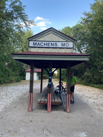
The Katy Trail runs 239 miles through the state of Missouri. It intersects farmland, small towns, tunnels and bridges while paralleling the Missouri River. The trail is comprised of crushed gravel and every time we have ridden on it, it has been dusty, hot and humid, and we still love it! The day we arrived we rode 22 miles from the RV Park to the start of the east end of the trail (Machens.) The next day we rode from the campground to Weldon Springs Conservation area. Both rides were exceptional.


St. Charles, MO
St. Charles is a great little town. They were preparing for an Oktoberfest when we were there and had a sponsored ride called Pedal for a Cause on the day we were leaving. We had dinner the second night at Tony's Main Street. The Italian salad was delicious, the pizza was pretty good. We sat outside on New Orleans style balcony overlooking the street. It was lovely.


Katy Roundhouse, New Franklin, MO

This campground is right on my favorite section of the Katy Trail. It has no amenities to speak of besides full hook-ups. But it is peaceful, convenient to the Interstate and the owner is very nice and helpful. I would definitely stay here again.
We rode from the campground towards Rocheport. In total we rode 35 miles with a stop for lunch at the Meriweather Cafe and Bike Shop in Rocheport. Delicious food and beer. Delightful lunch stop. Beautiful September day.


Smoky Hills RV Park, Junction City, KS
We stayed here just for one night. It was a nice little park right off the interstate. It had a very nice laundry room which I made good use of. Sites were flat with easy in and out access. It was well designed. On the north side of Junction City was a trail along the river called the River Walk. It wasn't particularly scenic but it was nice to have somewhere to go to stretch our legs a bit.
Shady Grove Campground, Seibert, CO
This campground was an okay overnight stop. Sites were very close together and there was really nothing in the town. We walked around town a a bit, were barked at by an aggressive dog and returned to our camp site.
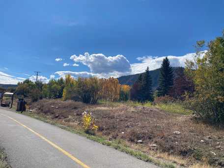
KOA West Glenwood Springs, Silt, CO


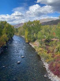
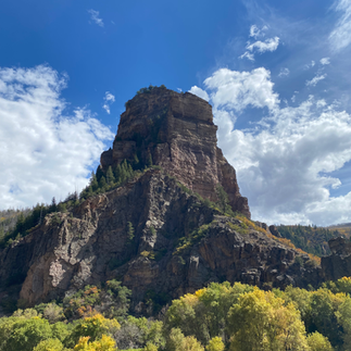
The KOA West is quite enjoyable. The campsites are well spaced for a KOA. We stayed at a site with a patio, which was very pleasant. A river also runs by the campground. While we had to drive a bit to reach Glenwood Springs, it wasn't too far. Silt was very nearby. We dined at the Miner's Claim Restaurant and enjoyed one of the best meals of our entire trip!
Named for the Rio Grande Railroad, the 42-mile trail goes from Glenwood Springs to Aspent. It follows the Roaring Fork River and Route 82 before it turns east and continues to parallel Route 82 to Aspen. We drove to Basalt and rode from there to Aspen - 42 miles round trip, 1,300 plus gain in elevation. Absolutely beautiful ride. There was always something interesting to look at - rivers, mountains, coyote, flock of turkeys. I say this a lot but it was one of my favorite rides ever!


The trail is 15.5 miles long and runs between Glenwood Springs and Dotsero. The trail is very unique in that it runs next to and under Interstate 70 on one side and the Colorado River on the other. It gets a bit congested with bicyclists and caution is advised as it isn't a terribly wide trail and has many blind curves. I thought it was really fun to ride.
At the end of our ride we went to the Glenwood Springs Hot Springs. It was well worth the price of admission! The resort includes a lodge in addition to multiple hot springs pools. At the center of the property is the Grand Pool, the world's largest hot springs pool (two city blocks in length) and next to another historic 104-degree therapy pool. There were a total of six hot springs pools.


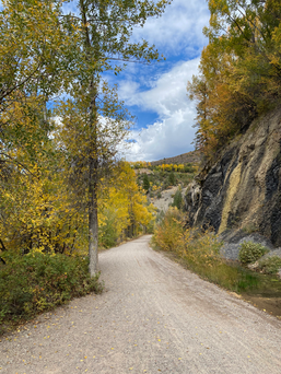
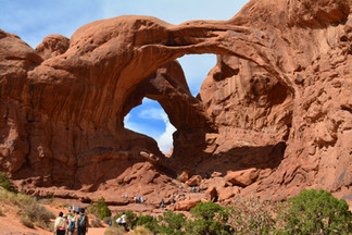
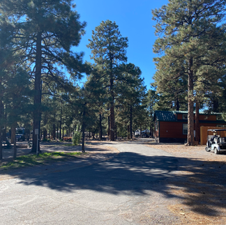
Sun Outdoors Arches Gateway, Moab, UT

This is one of several Sun Outdoors Campgrounds in the Moab area. It had very good views of the surrounding rock formations. The campground had a pool, hot tub, and laundry room. It was right on the Moab Canyon Pathway (bike trail). The sites were fairly close together and all sites faced another site. In some ways that's great - you aren't looking at someone else's hook-ups - but in other ways it is a bit awkward if everyone is hanging around outside. We were not at our campsite very much so it wasn't a big deal to us. I believe this is the closest campground to Arches National Park - only three miles to the Visitor's Center. The Moab Canyon Bike Path goes right by the national park.
Of the four national parks we toured, Arches was probably my least favorite. Nevertheless, I thoroughly enjoyed it. Most of the Arches and other rock formations can be easily viewed by taking relatively short hikes. Our entry time was at noon, and we spent a good 4-5 hours in the park. During that time, we felt we saw everything we wanted to. It is indeed a beautiful place.


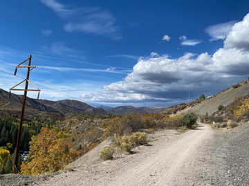
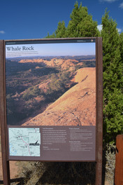
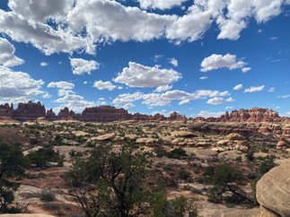
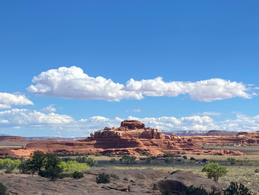
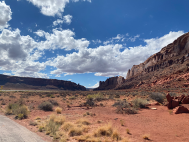
Canyonlands is super huge and has more than one entrance. We spent a good part of one day at the Island in the Sky area and another day at the Needles section of Canyonlands. I really loved Canyonlands. It was less crowded and there were some spectacularly awesome vistas, hikes, and arches.
Island in the Sky Area
In Island of the Sky the overlook from the Visitor Center is fabulous. In addition don't miss Mesa Arch - probably my favorite of all the arches.


Needles Area of Canyonlands
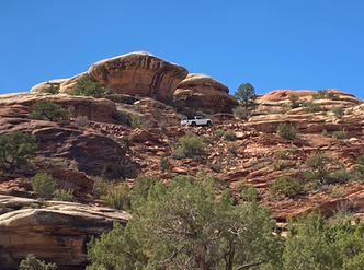
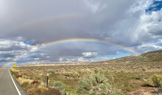
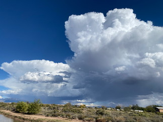
Needles was just as amazing. It's a beautiful place. We hiked the trail at the end of the Elephant Hill gravel road. Just to clarify, you can continue driving on Elephant Hill with a permit and a 4-wheel drive vehicle. We saw a truck climbing the side of the mountain—apparently on a road. Yikes! The trail we hiked was incredible, with each turn offering another breathtaking view. It helped that the day was picture-perfect with strikingly blue skies and fluffy clouds. To cap off our day, we saw a double rainbow on the way home.


The 13-mile trail runs along the southern border of Arches National Park. On the south end nearest to Moab it connects to the Colorado Riverway at the Bike/Hike Bridge (a spectacular structure) and runs for 2 miles along the Colorado River. The Pathway heads north and passes the entrance to Arches, continuing along Highway 191. The scenery is spectacular and diverts your attention from the challenging 1.3 mile climb with a 7% grade. On the North end the Pathway ends at Highway 313. We rode on Highway 313 for a couple miles. It continues on another 24 miles to Deadhorse State Park.


Moab
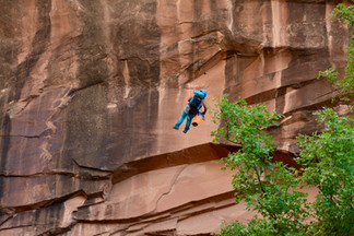
Moab has a super outdoorsy vibe to it. Everyone, it seemed, were either riding their bikes or hauling them somewhere to ride. We enjoyed the two breweries we went to - Proper Brewing (almost next door to the campground) and Moab Brewing. We did a hike just outside of Moab called Grandstaff Canyon Trail. It was about 4.5 miles roundtrip and led to a natural bridge. The day we were there people were rappelling off the bridge. Very fun to watch.


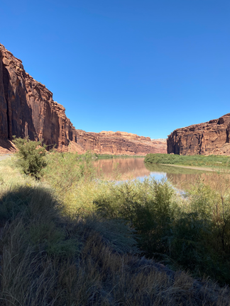
We also ventured into the Potosh Road area on our bikes. Located just north of Moab, Potosh Road features a wide shoulder ideal for biking and is not overly crowded with vehicle traffic. The road runs between rock cliffs and the Colorado River, offering a very scenic view. There are several spots where petroglyphs can be seen. It is widely believed that most of these petroglyphs were created by the Indians of the Southern San Rafael Fremont Culture, while the more recent ones are attributed to the Ute Indians.
Rock climbers often visit the rock walls along Potosh Road, known as Wall Street. The road concludes at the access point to Shafer Road, which eventually leads to Canyonlands, and also provides access to Long Canyon Road. We rode a bit on both roads with our gravel bikes, but progress was slow! Both roads are popular among jeeps and other 4-wheel drive vehicles.


Ruby's Inn RV Park and Campground, Bryce City, UT


Ruby's has the accommodations closest to the entrance of Bryce Canyon National Park if you don't have reservations within the park. The park has lodges and cabins and a campground with no hookups. We made the decision to camp at Ruby's since they have full hook-ups and we planned to stay for a week. Ruby's is a huge complex and there are tons of camping spots. The spaces were very tight - some almost impossible to navigate given the trees lining the sites. There were large sites at the back of the campground which I might explore if we return.
There are a few restaurants associated with Ruby's and a nightly musical event at Ebenezer's Bar and Grill that included dinner and a show which was fun. We went to a cute little coffee shop called Bryce Canyon Coffee Company in Tropic one day and had a great lunch in Panguitch at the Flying Goat Cafe.
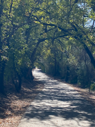
The best part of staying at Ruby's is that we could ride our bikes into the park on the path, park them at the trailheads and hike. We avoided all the traffic coming and going from the Park. The path is five miles long currently, but they are working to extend it further into the park. The trail has many curves and hills and is much more interesting than my pictures show.


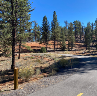


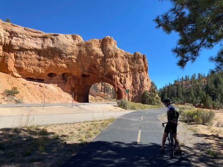
The trail is 13 miles one way and connects Bryce Canyon Park to Red Canyon, a part of the Dixie National Forest. It was very scenic the last four miles into Red Canyon. The trail was curvy, hilly and went in and out of the forest. The first part of the trail out of Bryce City was not terribly scenic and not in the best shape. There were many headache-inducing cracks in the pavement which I imagine wouldn't be so noticeable on either e-bikes or mountain bikes. Red Canyon was very pretty.


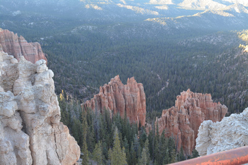
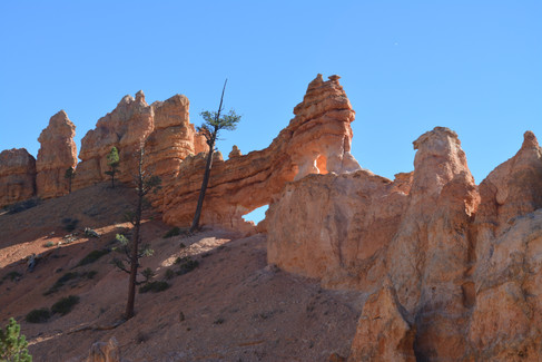
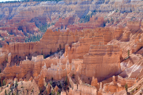
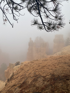
My favorite of the four southern Utah national parks we visited! I couldn't get over the hoodoos and how the entire landscape looked fake - like some giant had built a bunch of red sand castles. We hiked most of the trails in the park. I particularly loved the Peekaboo Trail. The Queen's Gambit and Navajo Trails are beautiful and the most popular so they were pretty crowded. We hiked the Tower Bridge Trail which was not crowded at all. We also drove to Tropic (a small town off of scenic highway 12) and hiked up through the hoodoos from the east end of the park. We hiked Mossy Cave Trail, a short and fairly easy trail, accessible about four miles out of the park on Highway 12. In the days we were there we rode our bikes to all of the overlooks - each one unique in its own way - and hiked along the Rim Trail. I apologize in advance for all the photos!


Zion Canyon Campground, Springdale, UT


This campground was conveniently located just outside Zion National Park. We could walk to the park shuttles or take the Pa'rus Trail from near the campground into Zion. Zion doesn't allow cars, only shuttles, during certain times of the year which makes it great for bicycling into the park. Be sure to pull over when the shuttles pass - the shuttle drivers were unhappy with cyclists who did not pull over.
Besides being conveniently located, the campground sites were large enough, trees provided some shade and you couldn't beat the views. There was a nice laundry room, pool and hot tub.
Pa'rus Trail and Road into Zion National Park
The Pa'rus Trail follows the Virgin river through lower Zion Canyon linking up with the road into and through the National Park. We rode into the Park nearly every day we were in Zion. We would ride to a trailhead and lock up our bikes in the rack and take off on a hike or to an overlook. Every time I rode into the park I felt like I had won a lottery I didn't even enter. I would 100 percent recommend bringing your bikes or renting bikes to be able to ride traffic-free into the park.


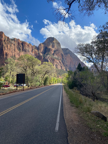


Zion is stunning. The views and hikes are incredible. I enjoyed every moment we spent there. On the first day, we drove along tunnel road, passing through the tunnel towards the park's East end. This section of the national park allows car access. We attempted to park and hike the Canyon Overlook Trail, but there were no available spots. So, we continued to the park's end and hiked the East Rim Trail, which turned out to be a great decision. This trail doesn't receive much attention, but at about 2.2 miles in, there is a breathtaking view of the Checkerboard Mesa and Canyon. The trail was quite empty; we saw a couple of people returning as we started, and a few more as we were leaving.


Emerald Pools Hike is one of the Park's most popular hikes. We enjoyed it but it was crowded! On that day we also stopped to see the Court of the Patriarchs - three sandstone cliff peaks.


We hiked the Watchman Trail. It begins at the Zion Visitor's Center and climbs about 600 feet to offer stunning views of Springdale, the Watchman Spires and the Virgin River. Nice hike, less crowded.


Hiking the Narrows was definitely our most adventuresome activity. We rented waders, neoprene socks and walking sticks which was well worth the money. It was crowded, but so beautiful. We hiked about 2 1/2 miles into the Narrows and it got progressively less crowded the further we went. We are in fairly good shape and it was slow going for us. I guess that because of recent rains the water was very murky. We heard from others that when it's clear you feel a little more confident of your footing because you can see the large boulders in the creek. We had to step, steady ourselves, then step again. We were so slow at times that my apple watch didn't even register that I was moving! I'm very glad we did it. I would like to do it again when it's a bit warmer out.


Kolob Canyon is part of Zion National Park located about 40 miles north of Zion Canyon. We hiked the Taylor Creek Trail which was nearly 6 miles long and then the Lee Pass Trail leading to a fantastic overlook. It was well worth the drive to explore this area.


Springdale, UT
Just a note on Springdale. It's the town closest to the main part of Zion. Shuttles run continuously from various stops in the town to the Visitor's Center where the National Park shuttles take people in and out of the Park. The town has many great restaurants and a nice grocery store. We had dinner at the Zion Canyon Brew Pub (a welcome respite after our Narrows hike), the Wild Thyme (fantastic dinner), and brunch at Oscar's (delicious). I thought it was worth it to stay in Springdale as parking is limited for people driving in from somewhere else. We could bike or walk everywhere we wanted to go.
St. George, UT
We had heard great things about St. George and the many bike trails. We went over on a rainy day, but did manage to get in a bike ride on the Virgin River Trail. It was a nice trail - fairly urban, but with good views and interesting things to look at. It would be a fun place to explore in more depth at some point.
Capital Reef National Park
We did not make it to Capital Reef. We had intended to go from Bryce Canyon NP but it rained on the day we had set aside to go. Next time.
KOA Holiday, Flagstaff, AZ
This was a good campground. We were on the edge of a row with a patio and chairs. The site was both spacious and private. The campground is next to the Coconino National Forest with trails running from the campground into the National Forest.
We made the most of our two days in Flagstaff.
Hiked up to Mt. Elden in the National Forest - six miles roundtrip straight uphill and back down
Had dinner and some good beers at Dark Sky Brewing Company in Flagstaff
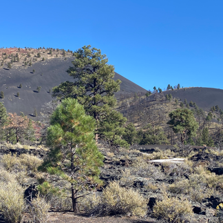
Visited Sunset Crater National Park - a thousand years ago lava erupted and created the most amazing landscape. Now trees and flowers grow among the rocks and it is a monument to the most recent volcanic eruption in Arizona. So cool!
Wupatki National Monument - very well preserved Pueblo community ruins from the 1100s. There is a visitor's center but it wasn't open because of the government shutdown.


Turquoise Trail Campground, Cedar Crest, NM (just outside of Albuquerque)
The campground's sites were large and spaced well apart. The Cibola National Forest buts up against the campground which was great.
We hiked twice in the Forest
Biked the 17-mile Paseo del Bosque rail trail in Albuquerque - really nice trail
Visited Santa Fe for a day


Amarillo RV Park, Amarillo, TX
The campground was just fine for a two night stay. It's basically a large parking lot, but the sites are well spaced and large. There is a hot tub, pool and workout space at the campground. It was very convenient to the interstate but not noisy.
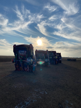
One of the reasons we paused for two nights was to go to Palo Duro State Park. I had been reading about it and was interested in the fact that in the panhandle of Texas exists this enormous canyon. It did not disappoint! Amarillo is so flat - flatter than the prairies of Illinois if that is possible. And then all of sudden you get to Palo Duro which is a huge canyon - the second largest in the country in fact. We hiked to the Lighthouse Rock - six miles roundtrip - and loved every minute of it! And bonus - on the way back we stopped at Cadillac Ranch.


Rockwell RV Park, Oklahoma City, OK
I'm not sure I would recommend Rockwell RV Park but I guess it was okay for a one night stay. We choose it because there is a bike path right next to the campground but the gate access was locked and there wasn't an easy way to get to the path. We drove a short way and found a path around Lake Overholser.
Route 66 KOA, Springfield, MO
Route 66 KOA is a nice campground. We had a good site at the end of a row. The campground was smallish but well kept. It rained the whole time we were there so we didn't explore much. We did eat dinner at Lindbergh's Tavern. Very cool, dark, old tavern. Apparently it was a railroad workers' tavern. They would cash the workers' checks and then they spent their money at the tavern. It was a cool building and very good food!
I55 RV Campground, Edwardsville, IL
This campground was literally built in a cornfield. It looked fairly new and definitely needs a noise barrier of some sort. I could hear interstate traffic nearly all night. There are no facilities and only 20 or so full hook-ups. There is a very nice bike trail system in and around Edwardsville. We didn't ride as it was pretty cold, but we did go for a run on the trails. They were accessible via the country road on which the campground was located.
Home
This was such a fun trip. We were expecting to like the Utah National Parks, but were surprised at how much fun we had in Glenwood Springs, Flagstaff, Albuquerque and Amarillo. Sometimes the most joy comes from the unexpected!


Thanks for your post! Lots of great info and awesome pictures. Our home is in St. Charles, MO, so we are familiar with several of these campgrounds. Others, we've seen on our travels. Like you, we still have our home base, but we travel much of the year - for fun and also as volunteers for NPS. Next Fall, we'll be at the Grand Canyon (God willing!) and hope to visit the NPs in Utah while we are there. I did wonder about Rockwell RV Park in Oklahoma City. I'm the author of "RVing with Bikes" ebook - which is now also an app. I don't have this campground listed as one where you can camp and ride …